US Paralyzed by Monster Blizzard ‘Fern’: GLOBAL WEATHER ALERT, Northern India Battling Severe
Monster Blizzard ‘Fern’ in US: Northern India Battling Severe Himalayan Whiteout

The Global Freeze: A Simultaneous Atmospheric Assault
As dawn breaks on Saturday, January 24, 2026, the world is witnessing a rare and punishing synchronization of severe winter weather systems on opposite sides of the globe. In the Western Hemisphere, the United States is currently besieged by what meteorologists are calling ‘Winter Storm Fern,’ a monster low-pressure system stretching over 2,000 miles from the Southern Plains to the Northeast.
Simultaneously, in the Eastern Hemisphere, Northern India is reeling under the impact of an intense Western Disturbance that has unleashed the season’s heaviest snowfall across the Himalayas. This dual-hemisphere freeze has disrupted the lives of over 300 million people combined, creating a complex web of logistical nightmares, infrastructure failures, and emergency mobilizations.
The scale of these events is staggering not just in their geographical reach but in their intensity. In the US, the threat is multi-dimensional: a crippling ice storm is coating the South, snapping power lines and turning highways into skating rinks, while the North faces blinding blizzard conditions with wind chills plummeting to -40°F. Meanwhile, the Indian subcontinent, typically accustomed to winter precipitations, is facing a ‘whiteout’ event.
The India Meteorological Department (IMD) has issued critical alerts for Jammu & Kashmir, Himachal Pradesh, and Uttarakhand, where snow accumulation rates are exceeding 2 inches per hour in higher altitudes. The synchronicity of these storms serves as a stark reminder of the interconnected nature of global atmospheric circulation patterns.
This manual serves as a comprehensive authority resource for navigating this global weather crisis. Whether you are a traveler stranded in Chicago, a resident bracing for power outages in Tennessee, or a tourist trapped in Manali, this guide aggregates the latest meteorological data, safety advisories, and future outlooks.
We will dissect the anatomy of both storm systems, analyze the catastrophic impact on aviation and ground transport, and provide expert-backed survival protocols for the next 72 critical hours. The situation is fluid and dangerous; understanding the mechanics of these storms is the first step toward safety.
Analysis of US Winter Storm ‘Fern’: The 2,000-Mile Behemoth
Winter Storm Fern is not a standard clipper system; it is a complex, multi-hazard event driven by the collision of Arctic high pressure and moisture-laden Gulf air. The National Weather Service (NWS) has characterized this system as ‘unusually large and severe,’ with impacts spanning from the Texas Panhandle to the coast of Maine.
The storm’s architecture is bifurcated: the southern flank is generating a destructive corridor of freezing rain and sleet, particularly devastating for states like Texas, Arkansas, and Tennessee, while the northern flank is dumping heavy, powdery snow across the Midwest and Great Lakes regions. The ‘Ice Corridor’ remains the primary concern for infrastructure stability. Meteorologists warn that ice accretion could reach up to one inch in parts of the Mississippi Valley.
To put this in perspective, just a quarter-inch of ice is sufficient to bring down tree limbs and power lines; an inch of ice can cause catastrophic, long-duration grid failures. Utility companies across the South have pre-staged thousands of line workers, but the continuous precipitation renders immediate repairs nearly impossible. In the North, the concern shifts to ‘flash freeze’ conditions, where wet surfaces rapidly freeze as temperatures nose-dive, creating invisible black ice on major interstates like I-90 and I-80.
The barometric pressure readings indicate the storm is intensifying as it moves eastward, a process known as cyclogenesis. This deepening low pressure is whipping up gale-force winds, creating blizzard conditions that reduce visibility to near zero. The NWS has issued Blizzard Warnings for parts of the Upper Midwest, advising that travel is ‘impossible and life-threatening.’
Residents in the affected zones are urged to shelter in place, as emergency responders may be unable to reach stranded motorists in the blinding whiteouts. The sheer breadth of the storm means that resources are stretched thin, with National Guard units mobilized in at least nine states to assist with welfare checks and emergency transport.

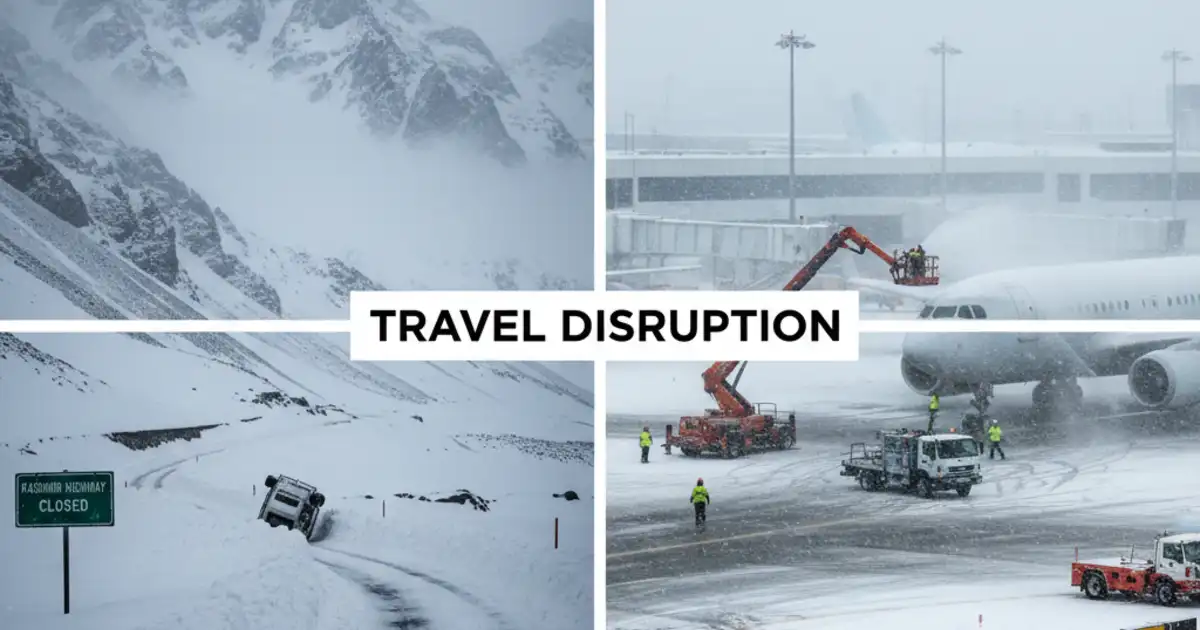
US Aviation Sector Meltdown: Flight Cancellations Top 2,000
The US aviation network has been dealt a crippling blow, with the ripple effects of Winter Storm Fern causing a systemic paralysis. As of Saturday morning, FlightAware data confirms that over 2,000 flights have been canceled, with another 5,000 delayed. The disruptions are centered around key transcontinental hubs, creating a domino effect that is stranding passengers as far away as London and Tokyo.
Dallas-Fort Worth (DFW), a critical fortress hub for American Airlines, has seen nearly 40% of its schedule scrubbed due to the ice threat, effectively severing a major artery of domestic air travel. Chicago O’Hare (ORD) and Denver International (DEN) are also reporting massive disruptions. At O’Hare, the issue is less about runway friction and more about de-icing logistics.
The rate of snowfall is so intense that aircraft are ‘timing out’ of their de-icing holdover times before they can reach the runway, forcing them to return to the gate for a second treatment. This logistical bottleneck has left thousands of passengers trapped on tarmacs or sleeping in terminal cots.
The Federal Aviation Administration (FAA) has issued ground stops for multiple airports, citing ‘severe weather avoidance plans’ (SWAP) that severely restrict the number of planes that can enter affected airspace. Airlines including Delta, United, and Southwest have issued broad travel waivers, allowing passengers to rebook without penalties. However, the sheer volume of displaced travelers means that available seats for the coming days are non-existent.
Industry analysts predict it could take until mid-next week for the system to recover fully. Passengers are strongly advised *not* to head to the airport unless their flight status is confirmed as ‘On Time’ and they have verified that their connecting hub is operational. The current situation is a ‘tactical nightmare’ for airline operations centers, who are struggling to reposition crews and aircraft out of the storm’s path.
As the world moves through late January 2026, a rare and simultaneous eruption of extreme winter weather has gripped two of the world’s most populous regions. In a striking display of atmospheric volatility, Northern India is currently bracing for its most significant snowfall event of the season, while the United States battles a ‘monster’ winter storm that has already triggered states of emergency across 16 states.
The coincidence of these severe weather systems has created a global travel nightmare, grounding thousands of flights and putting millions of citizens under safety advisories. Meteorologists are calling the situation in the Northern Hemisphere ‘highly dynamic,’ with jet stream patterns buckling to allow polar air to plunge deep into temperate zones.
In the US, a massive system is tracking a 2,000-mile path of destruction from the Southern Plains to the Northeast, threatening ice storms in Texas and blizzard conditions in New England. Meanwhile, a potent Western Disturbance interacting with moisture from the Arabian Sea is burying the Indian Himalayas in fresh powder, disrupting life from Kashmir to Uttarakhand.
This comprehensive report delves deep into the unfolding crisis, offering granular details on the forecast, the infrastructural impacts, and the critical safety measures required for those in the affected zones. Whether you are a traveler stranded in an airport lounge in Chicago or a tourist looking at a closed highway in Manali, this guide covers the full scope of this January 2026 weather event.

The US ‘Monster’ Storm: A 2,000-Mile Path of Ice and Snow
The storm system currently ravaging the United States is being described by the National Weather Service (NWS) as a ‘multi-hazard event.’ Originating from the Rockies, the system has intensified rapidly as it moves eastward, drawing moisture from the Gulf of Mexico and colliding with an Arctic high-pressure system descending from Canada. This collision has created a perfect recipe for disaster, manifesting as a heavy snow band to the north and a crippling ice storm to the south.
States such as Texas, Oklahoma, and Arkansas are currently bearing the brunt of the icy conditions. Freezing rain warnings are in effect for millions, with ice accumulation expected to exceed half an inch in some areas—enough to snap power lines and topple trees. The power grid in these regions, particularly in Texas, is under immense strain as temperatures plummet well below freezing, prompting officials to issue urgent conservation requests.
Further north, the story is one of heavy, blinding snow. Cities like Chicago, Detroit, and eventually Boston and New York are in the crosshairs of the storm’s snowy side. Forecast models predict accumulation totals ranging from 12 to 18 inches in the hardest-hit corridors. The sheer volume of snow, combined with wind gusts topping 50 mph, is creating whiteout conditions that make road travel virtually impossible.
Highway authorities have already reported hundreds of accidents and are imploring residents to stay off the roads until the system passes.
Aviation Crisis: 6,000 Flights Grounded and Counting
The ripple effect of the US storm on global aviation has been instantaneous and severe. As of Saturday morning, flight tracking services report that nearly 6,000 flights have been canceled within, into, or out of the United States for the weekend of January 24-25. Major hubs, including Dallas-Fort Worth (DFW), Chicago O’Hare (ORD), and Denver International (DEN), are operating at a fraction of their capacity, with runways closing intermittently for de-icing and snow clearing.
Airlines including Delta, American, United, and Southwest have issued sweeping travel waivers, allowing passengers to rebook without penalties. However, the sheer volume of displaced travelers means that rebooking options are scarce, with many passengers facing delays of 48 to 72 hours.
The situation is further complicated by crew displacements; with pilots and flight attendants unable to reach their base airports, delays are cascading through the network, affecting flights even in sunny locations like Florida and California. Travelers are advised to check their flight status digitally before leaving for the airport. The Federal Aviation Administration (FAA) has issued ground stops for several key airports, and these are likely to persist through Sunday.
For those stranded, airport hotels are reaching maximum occupancy rapidly, creating a secondary logistical challenge for thousands of families attempting to return home from holiday travel or business trips.

Northern India’s Whiteout: The Western Disturbance Strikes
While the US grapples with its blizzard, Northern India is facing a formidable winter challenge of its own. A strong Western Disturbance—an extra-tropical storm originating in the Mediterranean region—has moved across Pakistan and is now squarely over Jammu & Kashmir, Himachal Pradesh, and Uttarakhand. This system is dumping heavy amounts of snow on the middle and higher reaches of the Himalayas, ending a prolonged dry spell but bringing immediate disruption.
In the Union Territory of Jammu & Kashmir, the famous tourist destination of Gulmarg has received over two feet of fresh snow in the last 24 hours. While this is a boon for the skiing industry and future water reserves, it has paralyzed current infrastructure. The Jammu-Srinagar National Highway, the sole all-weather road link connecting the Kashmir valley to the rest of the country, has been blocked by landslides and slippery conditions at key points like Banihal and Ramban.
The India Meteorological Department (IMD) has issued an ‘Orange Alert’ for several districts, warning of potential avalanches in high-altitude areas. Local administration has deployed disaster management teams to clear snow, but continuous precipitation is hampering efforts. Essential supplies are being stocked, but remote villages risk being cut off for days if the intensity of the snowfall continues as forecast.
Srinagar Airport Shutdown and Tourism Impact
The impact on connectivity in Northern India has been severe. Srinagar’s Sheikh ul-Alam International Airport suspended all flight operations on Friday and early Saturday due to poor visibility and snow accumulation on the runway. This cancellation has left thousands of tourists stranded in the valley. Hotel associations in Kashmir report a chaotic situation with 1,500 room-night cancellations in a single day, a significant economic blow during what is typically a peak winter tourism window.
Airlines operating in the region, such as IndiGo and Vistara, have advised passengers to defer travel plans. The cancellation of flights has also led to a surge in demand for road transport, but with the highways compromised, travelers are effectively stuck. Authorities are urging tourists currently in hill stations like Manali and Shimla to remain indoors and avoid venturing onto trekking routes, which are currently treacherous due to soft, unstable snow.

The Plains of India: Cold Wave and Dense Fog
The impact of the Western Disturbance is not limited to the mountains. As the system moves away, it leaves behind moisture that, combined with plummeting temperatures, is creating severe cold wave conditions across the plains of Northwest India. Cities like New Delhi, Amritsar, and Jaipur are witnessing a sharp drop in mercury. The IMD predicts minimum temperatures could dip by 3 to 5 degrees Celsius over the next 48 hours, bringing near-freezing nights to the capital.
Accompanying the cold is the menace of dense fog. Visibility in parts of Punjab, Haryana, and West Uttar Pradesh has dropped to below 50 meters in the early morning hours. This has disrupted rail traffic, with Indian Railways announcing the delay of over 40 long-distance trains. Commuters in Delhi are facing hazardous driving conditions, and health advisories have been issued for the elderly and children to minimize exposure to the biting cold and pollutants trapped by the fog.
The ‘Chillai Kalan’—the harshest 40-day winter period in Kashmir—may be ending soon, but the residual cold sweeping through the plains ensures that winter’s grip will remain tight across North India through the end of January. Farmers are particularly concerned about the frost impact on crops like mustard and wheat, although the rain associated with the disturbance is generally viewed as beneficial for the Rabi season.
Meteorological Analysis: Why Is This Happening Now?
The simultaneous occurrence of these major weather events is a testament to the interconnected nature of the global climate system. Meteorologists point to a highly meandering jet stream as the culprit. In the US, the jet stream has dipped far south, pulling polar air into the Gulf States. This dip creates a boundary where cold, dry air meets warm, moist air, fueling the explosive development of the winter storm.
Similarly, the subtropical westerly jet stream over Asia is steering Western Disturbances with greater intensity into the Himalayas. Climate scientists also note that warming oceans are contributing more moisture to these systems, leading to heavier precipitation events. What might have been a standard snowfall a decade ago now has the potential to become a record-breaking dump due to the increased water vapor capacity of a slightly warmer atmosphere.

Safety Advisories and Survival Guide
For Residents in the US
If you are in the path of the storm, the primary advice is to stay home. If travel is absolutely necessary, ensure your vehicle is equipped with a winter survival kit including blankets, food, water, and a flashlight. Residents in ice-storm zones should prepare for potential power outages by charging devices and having non-perishable food ready. Avoid using gas generators indoors to prevent carbon monoxide poisoning.
For Residents and Travelers in Northern India
Tourists should avoid travel to higher altitudes until the weather stabilizes. Keep abreast of highway status updates via local traffic police social media handles. In case of heavy snow, stay indoors to avoid hypothermia or getting lost in low visibility. Residents using heating appliances like ‘kangris’ or gas heaters must ensure proper ventilation to avoid asphyxiation, a common winter tragedy in the region.
Forecast: What to Expect in the Next 48 Hours
Looking ahead to Sunday and Monday, the situation remains critical but evolving. In the US, the storm will migrate towards the Canadian Maritimes by late Monday, but not before dumping a final round of heavy snow on New England. Airport operations are expected to slowly normalize by Tuesday, though backlog clearance will take days.
In India, the Western Disturbance is forecast to move eastward, bringing rain to parts of Uttar Pradesh and Bihar while the snow in the mountains tapers off. However, the subsequent drop in temperature will lead to ‘Cold Day’ conditions in the plains. Travelers planning trips to the hills should aim for dates after January 27th, when roads are likely to be cleared and the skies sunny.
As extreme weather events become more frequent, staying informed through reliable news sources and official weather channels is the best defense. Whether facing a blizzard in Buffalo or a snowstorm in Srinagar, preparation and caution are the keys to weathering the storm safely.


Если вы пытаетесь найти непосредственные рейсы из Еревана в Европу или желаете знать, куда можно уехать из Еревана выгодно, имеет смысл обращать внимание на бюджетные предложения и аэропорты как Болгарии, Польши, так и Чехии. Максимально целесообразно выбирать низкие по цене авиабилеты из Москвы за границу, в том числе направления в Чехию, Новую Зеландию или даже Доминикану, а также последние предложения из Москвы позволят снизить затраты на перелете.
Для всех тех, кто летит из Ташкента, стоит знать о директ рейсах из Ташкента в Европу и разветвленной сети аэропортов ОАЭ и Израиля. На сайте [url=https://lowcostpro1.ru]самый дешевый авиабилет из москвы[/url] можно посмотреть свежую информацию и найти нужные авиабилеты в Прагу, Берлин или Анталию с оптимальными lowcost вариантами. Также не оставьте без внимания посмотреть аэропорты Англии, Норвегии и Албании, чтобы расширить диапазон направлений для бюджетных путешествий.
Hi Friends,
Thank you for sharing your own experience with dishamunch.com ! I love hearing how different readers adapt recipes and ideas to their own kitchens. Your tip about response is fantastic.
Thanks for contributing your perspective – it adds so much to our community!
– Dr. Pavitra Singh at DISHA (Divyang/disabled Identity Safety Help Association) Munch”